SINGAPORE - Singapore's weather was surprising in a number of ways last year, exhibiting temperature trends that differed slightly from those observed globally, according to weather and climate findings released on Tuesday (Jan 19) by the National Environment Agency's (NEA) Meteorological Service Singapore (MSS).
The first five months of 2020 were warmer than average but this was reversed in the second half of the year - particularly in June and September - with cooler than average temperatures being recorded over the island.
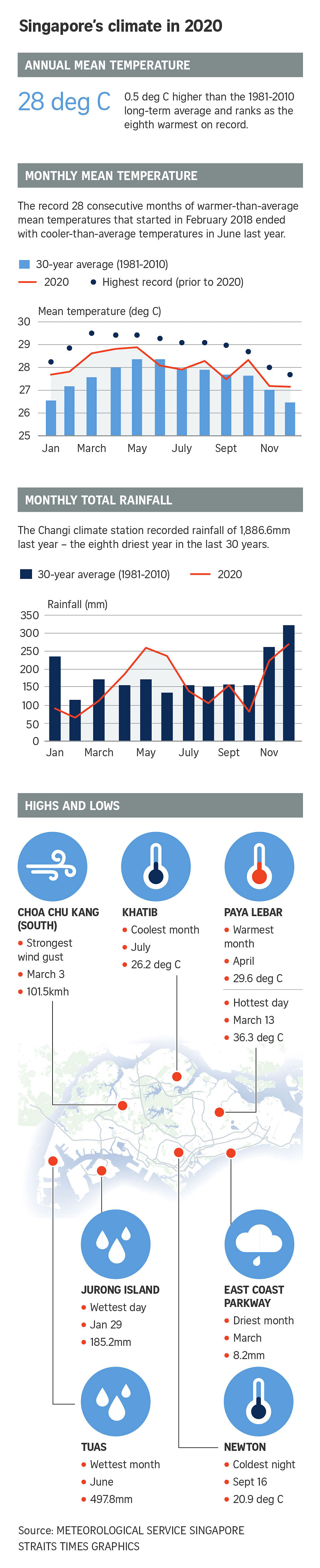
And even though it was marked by an unseasonably wet south-west monsoon season, last year was still the eighth-warmest year on record, with an annual mean temperature of 28 deg C - half a degree above the long-term average.
Last year also saw the continuation of a record 28 consecutive months of warmer than average mean temperatures on the island that started in February 2018 and came to an end last June.
These fresh findings that were released by the MSS on Tuesday indicate that Singapore's climate trends in 2020 differed slightly from those reported internationally in the latest State of the Global Climate 2020 from the World Meteorological Organisation (WMO).
On a global level, last year was one of the three warmest years on record, with the last decade (2011-2020) also being the warmest decade recorded.
In Singapore, rainfall fell below the long-term annual average; but the island also saw more frequent and intense heavy rainfall events, particularly in the second half of the year.
And while the south-west monsoon season (June to September) is normally the drier part of the year, those months were also unseasonably wet for Singapore and the surrounding region - due in part to La Nina conditions that developed in the third quarter of 2020.
This resulted in Singapore's rainfall for June to September 2020 being 30 per cent above the long-term average from 1981 to 2010.
Several other - also notable - weather events occurred last year.
June saw a total rainfall of 233.8mm, making it the wettest June in the last decade. The Changi climate station also recorded 21 days of rain, the highest in the last 30 years, with particularly heavy rainfall on June 23, which resulted in flash floods in Bedok and Jurong.
In October, the island also experienced a high frequency of Sumatra squalls, an organised line of thunderstorms that bring heavy rain and gusty winds. A total of 14 Sumatra squalls passed over Singapore that month alone, the highest number in a decade. This can be partly attributed to tropical cyclones over the South China Sea and the western Pacific Ocean.
Around 50 such Sumatra squalls crossed over Singapore in 2020, one of which resulted in the temperature dropping to 20.9 deg C in Newton on Sept 16, making that day the coolest of the year.
On average, Singapore experiences 45 Sumatra squalls annually, with most occurring between April and November.
So far, 2021 has been off to a chilly start, with temperature lows of 21.1 deg C recorded at Newton on Jan 2. This was accompanied by persistent wet weather, with the 318.6mm of rain that fell in Changi from New Year's Day to Jan 2 markedly more than the average of 238.3mm for the month of January.